 |
|||||||||||||||||
|
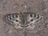
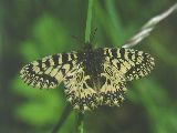
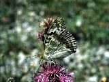
The butterflies - probably the best known group of invertebrates - are sensitive to environmental changes and therefore serve as most valuable indicators by providing indispensable information on the state of the environment in Europe under the impact of changing land use practices and other anthropogenic pressures. Numerous butterfly species are considered to be threatened by such pressures and many have been given legal protection on a regional, national, European or even world-wide scale.
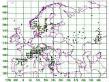
In spite of such conservation measures, until 1996 there had been no European data bank or adequate distribution maps enabling scientists and European authorities to assess the bio-geographical status and the degree of threat to the indigenous butterfly species. The distribution maps available in some field guides and similar books (e.g. HIGGINS & RILEY 1970 and subsequent editions) featuring roughly the western half of Europe reduced to the miniature size of 23 x 37 mm are useless because of their small scale alone; in addition to this they are hopelessly inaccurate. National data banks and distribution maps are no substitute for a European solution; quite apart from the fact that, even at the time of writing these lines in the summer of 2001, they are only available for some European countries and their standard differs to a great extent from case to case.
The first attempt to assess the status of European butterflies (HEATH 1981) was commissioned by the Council of Europe - and inevitably failed in every way (KUDRNA 1986). The European Invertebrate Survey (EIS) has never come near to fulfilling its 25 years-old pledge to produce a distribution atlas of European butterflies; the only attempt (HEATH & LECLERQ 1981) contains distribution maps of only 10 of nearly 500 species (i.e. just over 2 % of species) and these contain so many obvious errors, that they are also useless. The irresponsible approach of EIS towards its declared aims is most deplorable. Many governmental and non-governmental authorities throughout Europe are still taking EIS seriously, believing or assuming that EIS maintain comprehensive data banks and can provide expert advice on all questions concerning the distribution of European butterflies. Moreover, representatives of EIS are members of scientific committees regularly consulted by governments and European conservation authorities. In some countries, the existence of EIS alone serves as a convenient excuse for the state authorities not to support national recording schemes on the grounds that they would duplicate the work already carried out by the EIS. These facts are, particularly in view of many international conventions and EU legislation, very hard to believe but are sadly true.
Against this background the Naturschutzbund Deutschland e.V. (NABU) and the Gesellschaft für Schmetterlingsschutz e.V. (GfS) resolved in 1995 to start the project 'Mapping European Butterflies' (MEB) with the following main objectives:
Originally, it was intended to complete the project not later than in the spring of 2000. The great complexity of the project, building-up a team of recorders, the enormous amount of data received for processing and the time needed for their processing, soon proved the original timetable to be unrealistic. Despite the two years delay in the publication of the Atlas it must be pointed out that the project has been completed effectively and in a very short time. For this project the following definition of Europe was adopted: Europe is the westernmost extremity of the Euroasiatic landmass, bordered to the west by the Atlantic Ocean or adjacent off-shore seas and including adjacent off-shore islands. Included are all three Atlantic Ocean island groups: the Azores, Madeira and Canary Islands; excluded is Iceland which has no resident butterflies. The eastern border of Europe is marked by the Ural Mountains. The south-eastern border of Europe is (as usual) somewhat arbitrary: Ural Mts. - Ural River - northern and western Caspian Sea coast southwards to the town of Makhachkala - railway, road and oil pipelines from Makhachkala to the town of Mineralnye Vody - Nevinnomyssk - Armavir - Kropotnik - Krasnodar - Novorossiysk - northern Black Sea Coast south-westwards (including the Crimea) - eastern coast of European Turkey and Greece. Included are all Greek islands (regardless of how close to Asiatic Turkey they may be), Cyprus, Malta and all Mediterranean islands forming any part of the territory of any European country. Excluded is Asiatic Turkey (i.e. Asia Minor) and all African territories, including those under the administration of any European country.
The butterflies (Rhopalocera) are understood to comprise the superfamilies Papilionoidea and Hesperioidea. All European butterfly species recognised for the purpose of this project are listed separately, alphabetically arranged in an annotated catalogue. Records of exceptional or incidental migrants are not considered. Three recording periods are covered:
As the most recent records - in the first place those of the 3rd period and in the second place those of the 2nd period - are more important for conservation purposes than old records, the most recent record determines the symbol on the map. As there is no standard chronological classification of butterfly records in Europe, data banks of some countries extracted for MEB had to be adjusted to correspond with the above periods; these include those of the following countries: Austria, Finland, France and Switzerland. |
|||||||||||||||||


 Email to Webmaster